
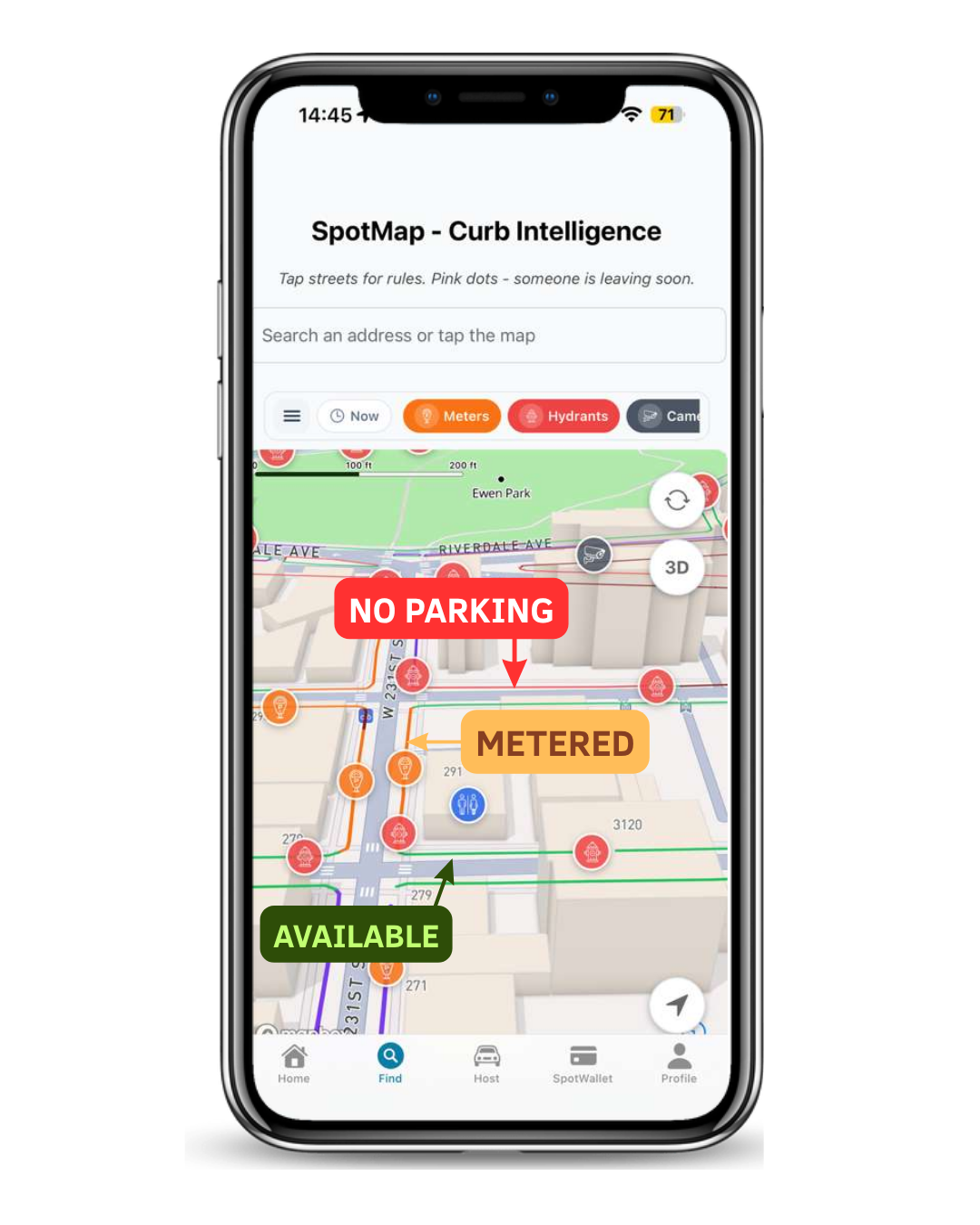
Direct answer: SpotMap is Spotlink’s 2D and 3D NYC parking map. It gives drivers a visual way to review curb context before parking, including color-coded curb conditions and available layers for meters, hydrants, public bathrooms, and speed-camera awareness.
SpotMap is guidance, not a legal guarantee. A map color cannot account for every posted sign, temporary restriction, emergency condition, vehicle rule, or immediate street change. The driver must confirm the curb and current rules before leaving the vehicle.
What SpotMap shows
The current SpotMap interface presents NYC streets in an angled 3D view so blocks and curb segments are easier to distinguish than on a flat list of rules. Visible labels and curb colors help organize the question in front of the driver: does this segment appear available, metered, conditional, or restricted?
The map also provides controls for driver-oriented context. In the current interface, those controls include parking meters, fire hydrants, speed cameras, and public bathrooms. These layers help a driver inspect the block and plan the next safe step without treating every nearby marker as a parking decision.
How to read the curb without over-trusting a color
The supplied current product screen shows green for available-parking context, orange for metered context, and red for no-parking or restricted context. Read the text attached to the segment as well as its color. Then verify posted signs, arrows, days, hours, temporary notices, and the rules for your vehicle.
See the full guide to SpotMap’s green, orange, and red curb visualization for a practical block-check workflow.
A safer before-you-park workflow
Stop safely before interacting. Set the location or inspect the map only while lawfully stopped, or let a passenger handle the phone.
Find the exact curb segment. Confirm the street, side of the block, direction, and the segment nearest the vehicle.
Read the visual context. Use the curb color and label to identify available, paid, conditional, or restricted context.
Turn on only the layer you need. Check hydrants, meters, public bathrooms, or speed-camera awareness without confusing those markers with permission to park.
Confirm the real street. Posted signs, temporary restrictions, emergency instructions, and official NYC rules remain final.
SpotMap and CurbAI solve different parts of the decision
SpotMap provides the visual street and nearby context. CurbAI helps organize location-specific parking rules and timing into a clearer before-you-park answer. Used together, they reduce the need to get out, walk the block, and begin deciphering the situation only after the car is already stopped.
Where parking discovery fits
If a driver selects a reported Live Departure, Spotlink can provide turn-by-turn guidance toward that reported location. Arrival does not reserve the space or establish that the curb is legal. SpotMap and CurbAI are the next check when the driver reaches the block.
SpotMap questions
Does green mean I am guaranteed to park legally?
No. Green is available-parking context in the current visualization, not a legal promise. Confirm every sign, time window, temporary notice, and street condition.
Does SpotMap show every hydrant, bathroom, meter, or camera in real time?
No completeness or perfect real-time guarantee is made. Use the layers as useful location context and verify important details in the street or through official sources.
Can SpotMap reserve a street-parking space?
No. SpotMap provides parking and curb context. Public street space is not reserved or guaranteed.
Where can I compare Spotlink with meter and garage apps?
Use the NYC parking app comparison to choose between street-parking intelligence, meter payment, and off-street garage reservations.