Waze and Google Maps help you get there. Spotlink helps after you arrive. Navigation, traffic, directions, ETAs, and place discovery are different from deciding whether a NYC curb allows parking.
What Waze and Google Maps Are Good For
Waze is useful for driving routes and traffic awareness. Google Maps is useful for directions, route planning, place discovery, transit context, and destination search.
Where Spotlink Is Different
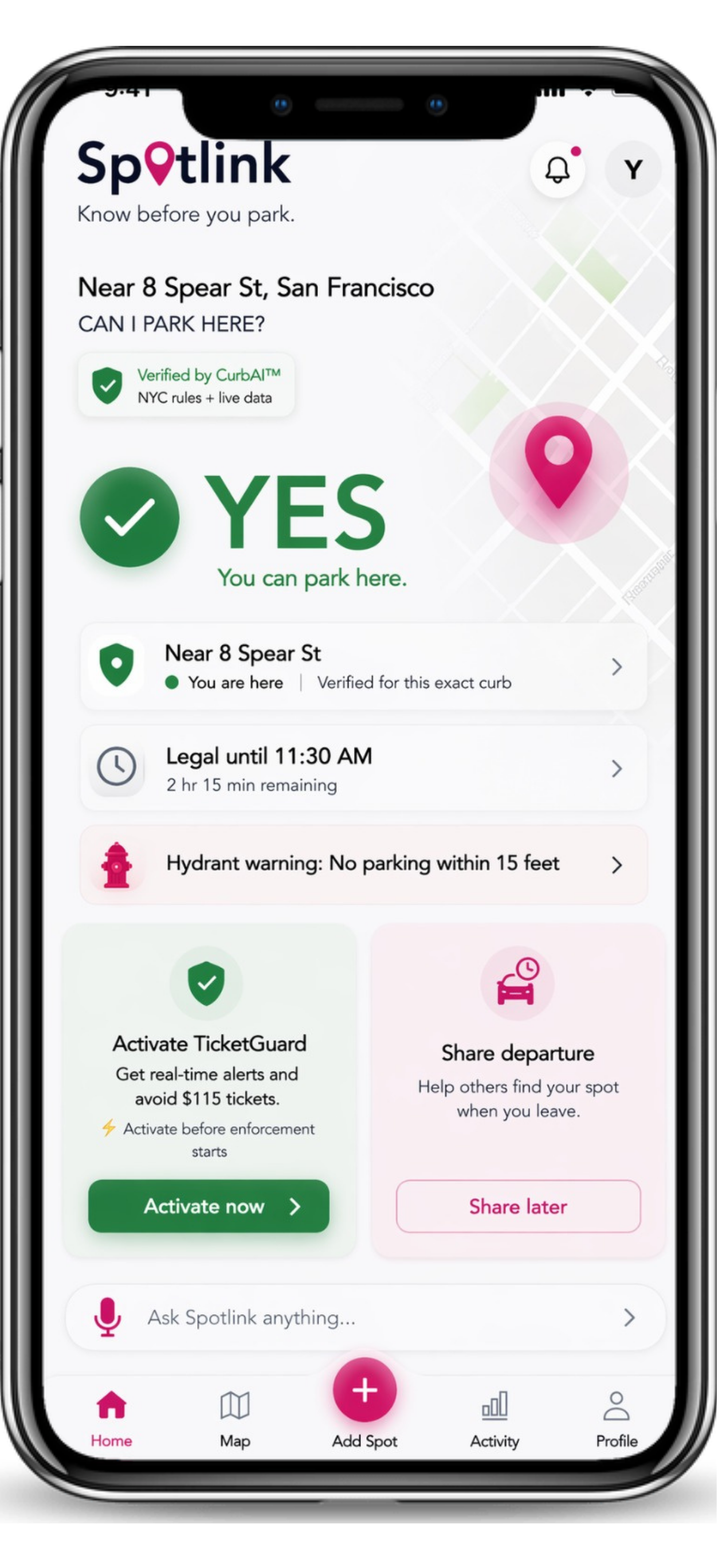
Spotlink focuses on the parking decision after navigation ends: signs, restrictions, hydrants, street cleaning, no standing, no parking, no stopping, temporary updates, and TicketGuard timing.
Driver-Need Comparison
Waze and Google Maps help drivers arrive. Spotlink picks up after arrival, when the question becomes whether the driver can park, wait, load, or leave the car.
| Driver need | Spotlink | Waze / Google Maps |
|---|---|---|
| Navigate / route | Not the main workflow | Primary use case |
| Traffic and directions | Outside primary focus | Primary use case |
| Check curbside sign rules after arrival | Primary Spotlink workflow | Limited / outside primary focus |
| Understand No Standing / No Parking / No Stopping | Plain-language rule support | Not built for this |
| Hydrant risk awareness | Part of the parking decision context | Not the main use case |
| TicketGuard alerts / timing awareness | Spotlink-style timing workflow | No Spotlink-style workflow |
| Save parking location | Supported in Spotlink | Limited / different use case |
| Share parking location | Trusted parking-location sharing | Limited / different use case |
| Live Departures | Community departure signals | Not built for curb departures |
| Voice questions / different languages | Ask parking questions by voice and language | General voice search differs |
| Temporary restrictions / local issue context | Driver decision support | Limited / outside primary focus |
| Practical “can I leave my car here?” support | Core Spotlink question | Not the main use case |
Practical Driver Examples
- Google Maps gets you to a block, but the open spot has a sign stack with different time windows.
- Waze helps avoid traffic, but you still need to know whether you can stop, wait, or leave the car.
- A hydrant, bus lane, temporary notice, or street cleaning window changes the decision after arrival.
- You are driving to a local business and need a faster answer before circling again.
NYC Parking Decision Context
Route guidance does not solve the final 50 feet of a NYC trip. Drivers still face posted restrictions, enforcement windows, changing rules, and daily uncertainty at the curb.
Ecosystem Impact
Spotlink adds an intelligent layer for urban mobility by helping drivers interpret parking context quickly. That can reduce stress, unnecessary circling, avoidable mistakes, and friction for households, workers, delivery drivers, and local businesses.
Next Step
Open Spotlink after navigation, before leaving the car.
FAQ
Is Spotlink a Waze replacement?
No. Waze is for routing and traffic. Spotlink is for NYC parking rules and curb decisions.
Is Spotlink a Google Maps replacement?
No. Google Maps is for directions and places. Spotlink helps with the parking rule decision after arrival.
Should I use Spotlink after navigation?
Yes, especially when signs, hydrants, meters, or time windows make the parking decision unclear.
Does Spotlink replace official parking rules?
No. Spotlink provides guidance; official signs and rules remain the source drivers must follow.